Upper West Street

West Street begins at the junction with High Street and runs westward becoming the B2150 at the Green Man junction, continuing beyond the Village boundary and the junction with Fareham Road towards Denmead via Well Hill. Confusingly, West St is bisected at the junction with Green Lane where the latter has right of way, giving the impression when travelling west from the village centre that one is joining a different road. To reduce confusion we do talk about Upper West Street (being the easterly section) and Lower West Street the westerly section.

West Street generally is not so densely built as East St or High St and has mixed age and mixed sized buildings, varying from Manor Farm in Upper West Street and Weaverlands in Lower West Street to small cottages and terraces interspersed in both sections. There are important landmark buildings and there has also been infill building of homes like The Gardens and Coachman’s Halt terrace in Upper West St and Old Barn Crescent and The Maltings in Lower West St.

Photo: Upper West St, Hambledon | View along West St from East St looking west c1958. Here are signs of lively commerce with the Peoples Market a general store in the short parade of shops left including Lloyds Bank. Clarkes Stores is still in its early site on High St corner and the Copper Kettle cafe opposite. The No39 bus waits for passengers.
Photo: The Peoples Market, West St, 1960s | Over the doorway is: EST 1870

The first building on the south side of West St is the Grade II listed Peoples Market which continues to be a very important amenity for the village built on the site of the old Market House which fell down in 1819 and its ruins cleared. We are still searching for some indication of what the old Market House looked like and hopefully one day will be revealed.

Photo: Upper West St, Hambledon c1950 | View looking east by the entrance to Manor Farm

The row of terraced houses west of People’s Market were once commercial premises – up to the 1960s – housing the old Post Office (Grade II listed), a bank and a chemist. On the north side of West St close to High St is the building known as Knight’s Corner (2 West St, Grade II listed) which was the premises of George Knight’s Saddlery business and over time in the 20thC housed the Copper Kettle Café.

Photo: Knights Corner, Upper West St, Hambledon c1890 | View looking northwest along West St by the Peoples Market
Photo: Upper West St, Hambledon c1930 | View looking along West St showing the entrance to Manor Farm, the winterbourne ditch and the original thatch of the long barn, now used as housing. Goffins’ double fronted store is to the right. The famous Hambledon Hunt is in full cry.

Staying on the north side, the next building which today is a residential home with a Georgian-style double frontage was once a grocer and general store called Goffins (see photo) which closed when owner, Benjamin Goffin, sold up and emigrated to Canada in 1911. Running alongside is Vicarage Lane.

Photo: Upper West St, Hambledon c1905 | View of Manor Farm looking east across the farmyard

Across the street is Grade II * listed Manor Farm, the next oldest building in the village after the Church of St Peter & Paul. A Norman Hall House, it was at the disposal of the influential Bishop of Winchester who owned the Manor and as it is not a large building was probably used as a hunting lodge for sport in the Forest of Bere which in earlier times was much closer to Hambledon whose Commons included stretches of Bere Chace before Enclosure . The Farm has extensive grounds and some remaining out buildings though no sign today of the original thatched barn or the duckpond for which there is map evidence.

The old farmyard of Manor Farm is an extensive green space stretching to Coachman’s Halt and whose adjacent field is overlooked by two substantial attached houses, positioned safely above the flood watermark.

Photo: The New Inn c1900 | View looking west along West St, Manor Farm barn to the left and Bell Cottages distant right; the wall between them is the boundary with the allotments that gave their name to the council houses in today’s The Gardens.

Opposite the yard of Manor Farm is the building that used to house the New Inn which ceased its role as a public house in 1985 and was converted into apartments, partly accessed from Vicarage Lane and renamed Walnut Tree House. Next to Walnut Tree House is the authentically refurbished Westside Cottage, fully maintaining its historic village character.

The Gardens is a 20C development of 10 compact bungalows built for older residents in a secure cul de sac above the flood risk level. Its name is taken from the space on which it was built; this appears in a late 19C map as ‘allotments’ and photographs show this as a cultivated area before it was built on.

Of the four larger houses further west from The Gardens, Minna Bluff has the most history having been built by Antarctic explorer William Lashly for his retirement back to Hambledon in 1932 and named after a landscape feature of Antarctica. All are individual 20C architecture, again carefully sited above flood level.

Opposite this group of houses Coachman’s Halt is a late 20C development of terraced homes built on the old Bus Depot that accommodated the local bus service and at times the renowned Hambledon Horticultural Show. The house with frontage to the street, Southdowns, testifies to its previous use. A long track to the west of Southdowns leads up to the intriguingly named Barb Ridge built on the edge of Speltham Down. The other side of the track is occupied by the telephone exchange which used to be operated by well-informed village residents!

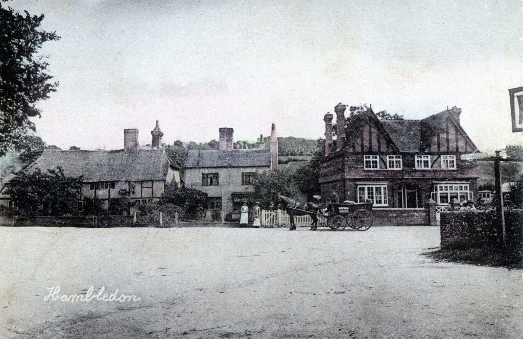
On the north side of the street here, set well back from the road is Little Symons, a classic English vernacular style house in large, landscaped gardens. Next to it, Well Cottage is a handsome flint and brick faced modern Georgian-style house maintaining village character and bordered to the west by Bell Cottages – named after the ale house, Bell Inn, that was demolished to make way for housing. The cottages are attached to The Vine public house – the only remaining pub in the village proper that at one time could boast nine or more such hostelries.

Photo: West St view looking east c1900 | The Vine public house is to the left and Vine Cottage to the right.
Photo: The Vine, West St c1960 | Opposite The Vine stand Vernon House and Vine Cottage.

Next door to The Vine is Hambledon Village Hall which is a well-used social centre and where local societies conduct their meetings in its rooms and in the refurbished wooden Pavilion. The safely-enclosed play area is a popular amenity for young families.

Hambledon Village Hall Official Opening | Official Opening programme
Photo: Hambledon Village Hall Official Opening | The new Village Hall was ceremoniously opened by Lady Salisbury-Jones on 18 September 1982

Opposite the Village Hall is Orchard House once one of two breweries in the village. It has a long history and after the brewery ceased operation in 1922 it became a handsome vintage family home.

Photo: The yard of Crowley’s Hambledon Brewery c1900 | Now; a private home, Orchard House; then, brewers are loading barrels of ale into the waiting carts.

Next to Orchard House are two more-recently-built houses, then the happily named Pleasant House, next to which is Hunters Cottage dating back to the 19C. A driveway to the west leads to Deepfield set well back from the road.

Opposite Hunters Cottage nestled into the corner of Upper West St and Green Lane are two modern houses built in the 1990s with a common drive. Whilst they look like quite typical modern homes, one of them, Upper Chapters has a unique and hidden secret. Older village residents remember a pond in the building site here but this feature doesn’t appear in any historic map, a natural conclusion being that the pond would appear and disappear according to the water table and also fed by the winterbourne that ran down West Street. Find out more about Upper Chapters story…

The last two houses of Upper West St are the picturesque timbered structures, Grade II listed Tudor Cottage and Bumblebee Cottage where, next to the latter, a side alley leads to Grade II listed 2 Crossways, set back behind Bumble Bee Cottage.

Photo: Upper West St viewed from The Green Man | A tantalising glimpse up Upper West St at the junction of Green Lane. The wall to the left is the boundary with Harfield House land; behind it was the pond which rose and fell with the water table. Foreground right is Tudor Cottage.

Scroll to Top